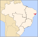
Barra de Santo Antônio
You can help expand this article with text translated from the corresponding article in Portuguese. Click [show] for important translation instructions.
|
Barra de Santo Antônio | |
|---|---|
 Location in Alagoas state | |
| Coordinates: 9°24′18″S 35°30′25″W / 9.40500°S 35.50694°W | |
| Country | Brazil |
| Region | Northeast |
| State | Alagoas |
| Microregion | Maceió |
| Area | |
| • Total | 138.43 km2 (53.45 sq mi) |
| Population (2020) | |
| • Total | 16,068 |
| • Density | 120/km2 (300/sq mi) |
| Time zone | UTC−3 (BRT) |
Barra de Santo Antônio is a municipality in the state of Alagoas in Brazil. The population is 16,068 (2020 est.)[1] in an area of 138.43 km².[2] The elevation is 10 m. It is situated on the Atlantic coast, northeast of Maceió.
External links
- citybrazil.com.br[permanent dead link] (in Portuguese)
References


